
| Weather Data | |||
|---|---|---|---|
| LAST READING AT TIME: 6:46 AM DATE: 23 June 2026, time of next update: 12:30 am | |||
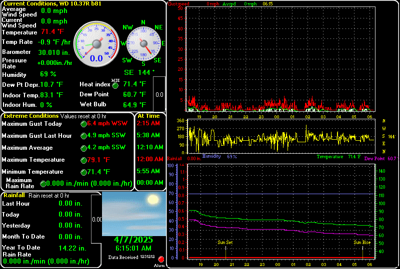
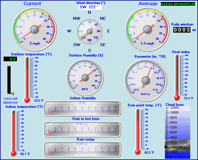
| Current Weather | Dry | Current Temperature | 58.3°F (14.6°C), Apparent temp 58.6°F |
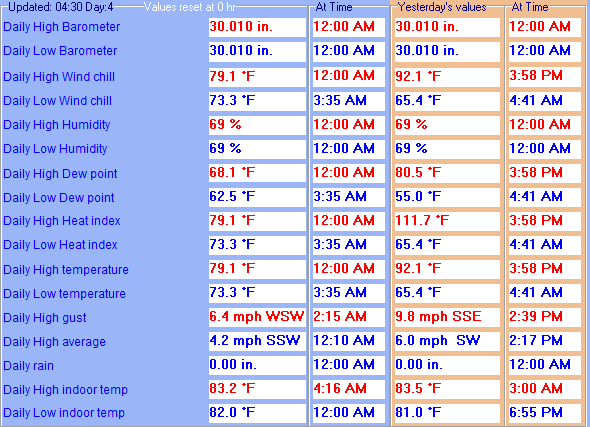
| Maximum Temperature (since midnight) | 65.6°F at: 1:15 AM | Minimum Temperature (since midnight) | 56.7°F at: 6:16 AM |
| Average windspeed (ten minute) | 0.0 mph | Wind Direction (ten minute) | SE (135°) |
| Windchill Temperature | 58.3°F | Maximum Gust (last hour) | 0 mph at: 6:00 AM |
| Maximum Gust (since midnight) | 7 mph at: 1:38 AM | Maximum 1 minute average (since midnight) | 5.0 mph at: 12:48 AM |
| Rainfall (last hour) | 0.00 in. (0.0 mm) | Rainfall (since midnight) | 0.00 in. (0.0 mm) --- |
| Rainfall This month | 1.66 in. (42.2 mm) | Rainfall To date this year | 1.66 in. (42.2 mm) |
| Maximum rain per minute (last hour) | 0.00 in/min | Maximum rain per hour (last 6 hours) | 0.00 in/hour |
| Yesterdays rainfall | 0.00 in | DewPoint | 48.2°F (Wet Bulb :53.1°F ) |
| Humidity | 69 %, Humidex 59.8°F | ||

Expires:202412200000;;035370
FPUS53 KDVN 191651
ZFPDVN

Zone Forecast Product
National Weather Service Quad Cities IA IL
1049 AM CST Thu Dec 19 2024


ILZ015-200000-
Rock Island-
Including the cities of Moline and Rock Island
1050 AM CST Thu Dec 19 2024

.REST OF TODAY...Cloudy. A slight chance of snow late this
morning, then a chance of snow with a slight chance of drizzle
this afternoon. Highs in the upper 30s. South winds 10 to 15 mph
with gusts up to 25 mph. Chance of snow 50 percent.
.TONIGHT...Cloudy. A chance of snow and rain in the evening, then
a slight chance of snow after midnight. Little or no snow
accumulation. Lows in the mid 20s. West winds 15 to 20 mph. Gusts
up to 35 mph after midnight. Chance of precipitation 40 percent.
.FRIDAY...Cloudy in the morning, then becoming partly sunny.
Highs in the lower 30s. Northwest winds 15 to 20 mph. Gusts up to
35 mph in the morning.
.FRIDAY NIGHT...Mostly cloudy. Lows around 17. North winds 5 to
10 mph.
.SATURDAY...Mostly sunny. Highs in the upper 20s. Northeast winds
around 5 mph.
.SATURDAY NIGHT AND SUNDAY...Partly cloudy. Lows 15 to 20. Highs
in the mid 30s.
.SUNDAY NIGHT...Mostly cloudy and not as cool. Near steady
temperature in the upper 20s.
.MONDAY...Mostly cloudy with a chance of rain and snow. Highs in
the lower 40s. Chance of precipitation 50 percent.
.MONDAY NIGHT THROUGH CHRISTMAS DAY...Mostly cloudy. Lows around
30. Highs in the lower 40s.

$$


MOLINE QUAD-CITY AIRPORT, IL, United States (KMLI) 41-27N 90-31W 184M
Dec 19, 2024 - 01:52 PM EST / 2024.12.19 1852 UTC
Wind: from the SSE (160 degrees) at 10 MPH (9 KT) gusting to 23 MPH (20 KT):0
Visibility: 10 mile(s):0
Sky conditions: mostly cloudy
Temperature: 36.0 F (2.2 C)
Dew Point: 27.0 F (-2.8 C)
Relative Humidity: 69%
Pressure (altimeter): 30.01 in. Hg (1016 hPa)
ob: KMLI 191852Z 16009G20KT 10SM BKN025 BKN090 BKN110 02/M03 A3001 RMK AO2 PK WND 16027/1822 SLP167 T00221028
cycle: 19
Use the RELOAD facility on your browser to retrieve the latest data.